
California Faces More Flooding in Latest Wave of Heavy Rains

(Bloomberg) -- California is facing another day of heavy rain and risks of flash floods, prompting officials to warn about the dangers for road travel in this busy holiday period.
A final wave in a system bringing bands of moderate to heavy rain will move across the state Friday, threatening flash floods across Southern California, according to the National Weather Service. The region may also see strong winds and thunderstorms near the coast.
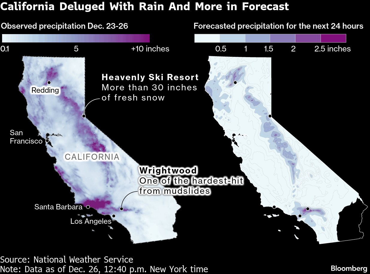
“We‘re on the backside of the storm now and rainfall is starting to taper off, but some isolated moderate to heavy showers are still possible through at least this afternoon,” the National Weather Service reported Friday morning local time. “It won‘t take much additional rain to create flooding issues today, especially in the mountains where some areas have received close to 18 inches of rain since Tuesday.”
The weather service retained flash flood advisories and watches for San Luis Obispo, Santa Barbara, Ventura and Los Angeles counties. More than 50,000 homes and businesses in the state were without power Friday afternoon, mostly in Northern California, according to PowerOutage.us.
The Los Angeles Fire Department deployed a helicopter to rescue a woman swept into a stormwater wash Friday.
Travel has been hobbled during the Christmas holiday with flight delays and waterlogged freeways. Flooding, downed trees, storm damage, debris and mud slides have led to dozens of road closures in the LA area alone, county data show, with further closures and disruptions reported throughout the state.
Several days of deluge have impacted LA areas that were devastated by massive wildfires roughly a year ago. The charred off vegetation makes the land resistant to soaking up the water, increasing the vulnerability toward landslides, mudslides and power outages. It’s a risk that will persist whenever especially heavy rains strike Southern California until the soil recovers and vegetation grows back.
“Those soils are still hydrophobic, which means that rain just runs off like it’s hitting hard dirt or concrete,” Scott Kleebauer, a meteorologist at the Weather Prediction Center, said this week. “There are burn scars that have lasted for four or five years before you see any improvement.”
The heaviest precipitation hit mountain areas of the Golden State, from the San Gabriel Mountains in the south to the Sierra Nevadas to the north. More than 6 inches (15 centimeters) of rain soaked Mount Baldy and Mount San Antonio east of Los Angeles, triggering mudslides in Wrightwood, where the 2024 Bridge Fire blackened 56,000 acres.
All lifts were closed at Mammoth Mountain ski resort, where the forecast called for 12 to 18 inches of fresh snow amid fierce winds gusting as high as 60 miles per hour. Heavenly Lake Tahoe ski resort was running nine of 27 lifts and reported 31 inches of fresh snow in the last 48 hours, with as much as 5 inches more forecast for Friday.
In the mountains, the weather service has warned of “near white out conditions at times” that will make travel dangerous and likely cause delays and road closures.
The historic rains started ravaging California earlier this week, with the storms killing at least three people.
More than 3 inches of rain fell in downtown Los Angeles over the three days through Friday morning. The weather service reported Thursday, when storm had dumped 2.59 inches downtown, that the Christmas Eve-Christmas Day holiday total had the most rain since 1971 and ranked as the fourth wettest two-day holiday period for downtown in records dating to 1877.
The heavy precipitation is the result of massive Pacific storms known as atmospheric rivers.
After Friday’s last band of storms, conditions are forecast to begin easing.
(Updates with Weather Service Comment in third paragraph and other details throughout)
©2025 Bloomberg L.P.


